
La Paz cable car map
The 10 lines and 26 stations of Mi Teleférico across La Paz and El Alto on a single map, with every interchange marked. Download it as a PNG or a PDF and carry it offline.
The cable car network map of La Paz
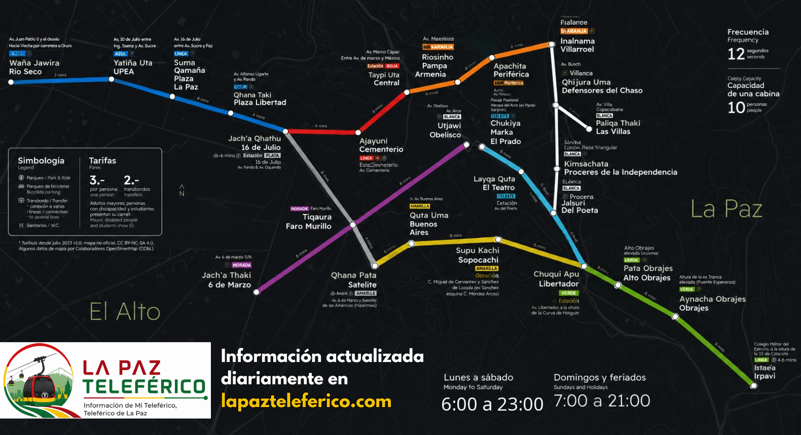
The map shows all 10 lines, every station and the interchange hubs. Remember the hours: 06:30 – 22:30 every day and 07:00 – 21:00 on public holidays.
Download the map in PDF
Get the Mi Teleférico map as a PDF: it stays sharp when you print it or zoom in, and it works with no signal at all — handy in El Alto and anywhere mobile coverage gets patchy. All 10 lines, the 26 stations and every interchange, in your pocket.
Legend: the 10 lines and their colors
The 8 interchange stations
Mi Teleférico has eight interchange stations. You change lines inside the station, without stepping out onto the street — but every extra line costs Bs 2 more. 16 de Julio and Libertador each connect three lines.
Frequently asked questions about the map
Right here: click the “Map in PDF” button and the file is saved to your device. A PNG version is available too. Both are free, print well and work offline, with no data connection.
The 10 lines in service and the 26 stations of the network (36 stops if you count each interchange platform separately), spread across La Paz and El Alto.
There are eight: Central (Red–Orange), 16 de Julio (Red–Blue–Silver), Mirador (Yellow–Silver), Libertador (Yellow–Green–Light Blue), Plaza Villarroel (Orange–White), Monumento Busch (White–Brown), Av. Poeta (White–Light Blue) and Faro Murillo (Purple–Silver).
No. San José (Purple Line) and Prado (Light Blue Line) are close to each other — a few minutes on foot along El Prado — but they are not an official interchange: you have to leave the station, walk, and pay a full new fare.
No. El Alto International Airport has no cable car station. Take a taxi or a minibus from La Ceja or Avenida 6 de Marzo.